The Ask
The brief came out of a conversation, not a spec. A Minneapolis client’s annual summit needed a thirty-second opener, and the idea was simple to say out loud: show every named lake in Minnesota as a star, let the density do the work, and let the audience realize they are looking at their own state about eight seconds in. I wrote that down in ordinary sentences, with the things I cared about (the timing of the recognition moment, the restraint, the accuracy) and the things I did not (the tech stack, the data wrangling, the math).
The Hand-Off
Fable took the plan and ran. It found the Minnesota DNR’s hydrography database on its own, downloaded it, and discovered the state’s lake data is richer than the folklore: the famous 11,842 number dates to a 1968 survey, and the modern data delineates 14,154 basins of ten acres or more. It flagged that discrepancy to me instead of hiding it, validated seventeen famous lakes against ground truth before drawing anything, and counted the Mud Lakes (177, if you are wondering).
"The interesting part was not that it wrote the code. It was that it checked its own work before I asked, and brought me decisions instead of problems."
When something needed taste rather than computation, it stopped and asked. Should Lake Superior be included? (We cut it. The state outline is stronger without it, and it is not really about Superior.) Should unnamed lakes count? (Yes. Otter Tail County’s bragging rights depend on them.) Those were my calls. Everything between them was not.
What Came Back
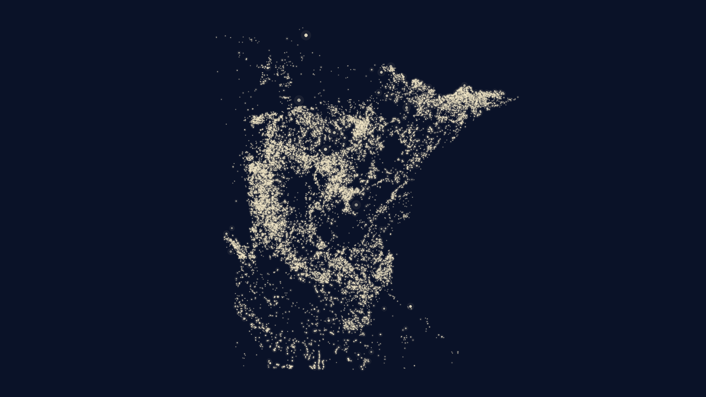
A single HTML file. No installation, no internet required, no dependencies. It opens to a dark field, and on a keypress the lakes bloom in over ten seconds until the state assembles itself out of light. Behind the show mode there is an exploration mode: search any of 8,584 named lakes and the panel draws that lake’s actual shoreline, with its acreage, depth, and one true superlative it earned from the data. Toggle all 177 Mud Lakes at once. Light up the lakes carrying Ojibwe and Dakota names. For lakes in the ten counties that publish sale records, the panel even shows recent shoreline sales, sourced from public county assessor data after Fable talked me out of scraping Zillow on legal grounds.
The Checking
The part I trust most is the part that came last. Before calling it done, Fable wrote an independent verification script that re-derived everything from the raw government sources and compared it against what the artifact actually displays: forty randomly sampled lakes checked field by field, shoreline shapes decoded and measured against the source polygons, sales re-derived from the parcel records. Sixty-one of sixty-two checks passed. The one failure was the checker’s own assumption, not the data: it flagged three lakes as impossibly deep, then discovered they are Cuyuna Range mine pits, which really are deeper than any natural lake in the state.
"Hands-off does not mean unverified. It means the verification is part of the hand-off."
What This Was Really About
This was an early exploration with a new model, and the finding is not about lakes. A working visualization of state-scale public data, validated, documented, and rehearsal-ready, used to be a small consulting engagement with a GIS specialist on the team. It is now an afternoon of describing what you want clearly and making good decisions when asked. The skill that mattered was knowing what to ask for and what good looks like. That is the shift I keep showing clients, and this time I have something they can touch.
Go find your lake.
Then imagine what a plain-English plan could build for your business.